Friday, October 28, 2011

Gettin' Crafty on the Butcher

Crafty Butcher double teeter-totter
So apparently there's some mountain biking to be had in Cumberland, BC. So says the map that shows the piled-spaghetti heap of trails just outside of town. So says the mud-splattered hordes of dudes and dudettes wheeling down the main drag on knobby-tired bikes of all description. So says the groups we've recently had here at the hostel, one of which traveled from Whistler to ride here, and another of which included a couple of national champions and the rep for one of the largest Canadian bike manufacturers. So says the organizers of the BC Bike Race, the 7-day-long epic torture test for masochists. So yeah, I suppose there's some mountain biking in the area.
Jessie demonstrating the angle on the wooden berm

"Most Trails are Advanced." That's the beginning of the Cumberland entry in the Mountain Bike Vancouver Island guide book, and let me tell you, they're not kidding! If you learn to ride here, you get really good, really fast. Rocks and roots and ridiculous steeps are prominent features of just about all the trails in the area. Oh, and what about the woodwork? There's a strong community of trail builders in the area who have put an enormous amount of work into building and maintaining all the singletrack, and many of the trails showcase their creativity and skills with a chainsaw. For example, "Thirsty Beaver" is a newer trail with oodles of bridges and ramps and skinnies, most of which go a long ways to keeping the trail sustainable through all the crazy and wet terrain that it traverses. And yes, there's the "Crafty Butcher", a trail with a double teeter-totter in the middle of it - just because. Why the heck not?!?
Railing the corner on the Crafty Butcher

And just in case you get tired of what Cumberland has to offer, all of the communities in this area are host to mountain biking trails of various degrees of epic-ness. Courtenay's Forbidden Plateau is apparently festooned with downhill-friendly trails. I haven't ridden there yet, and my intel is based on the trail maps and oh-so-handy guide book, but it's on my list. Again, "Most Trails are Advanced." Campbell River's Snowden Forest (which I have ridden, "Most Trails are Advanced") is swoopy, flowy, just-keep-pedaling double- and single-track. Just watch out for the arrows labeled "50 km." I started following them for lack of any other plan, and while I can't attest to the actual distance of the route, I can tell you that it keeps on going, and going, and going... And there's Quadra Island ("Most Trails are Intermediate"), where apparently "the fastest man in the world" and owner/operator of Naked Bicycles can be found leading group rides.
Old canoe
Derelict canoe on the shore of Morte Lake, Quadra Island
I haven't even come close to exploring all the trails in this area, but believe me, I'm gonna try!


Friday, October 7, 2011

Iceline - Celeste Lake - Yoho Valley loop

Iceline CairnJust getting caught up on posting some of my adventures from this summer...

In August I spent a few weeks in the Canadian Rockies, and if there's any place in the world that has more spectacular and varied hikes than here, I challenge you to tell me about it.

I started the Iceline hike a bit later in the day than I'd intended. I had planned to hit the trail in the afternoon, with the hopes of catching Takkakaw Falls with the late-day light that's more favorable for photography, but I got delayed by some unexpectedly nice views at Moraine Lake in Banff National Park, so it wasn't until after sunset that I returned to the Falls. But I'm getting ahead of myself...

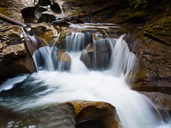
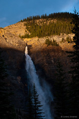
The Iceline Trail starts and ends at the Takkakaw Falls. They were spectacular, but I didn't take any pics as I set out on my hike. "Later," I told myself, since my folks had already taken many of those shots. So across to the Whiskey Jack Hostel, and up the trail I went. Steep at first, the trail switchbacked up and up and up... And the view of Takkakaw Falls kept on improving. And suddenly, I was clear of the trees.
Takakkaw from up high
Takakkaw Falls from up high
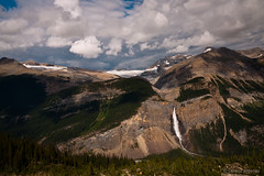
The Iceline trail is justifiably popular and well-traveled, although due to my late start I saw only a few people, all going the other way. (Hmmm... Did they know something I didn't?) The views of the surrounding mountain ranges and valleys - and yes, the Falls - were magnificent. Unfortunately, as I reached the high point of the trail I looked up to see ominous clouds spilling over the mountain's peak, and I was encouraged to find the quickest way down. The "quickest way" - and I mean quick, as I was chased by the darkening sky and the splatter of fat raindrops on the rocks - essentially meant running down the trail to Lake Celeste, and the subsequent trek along the Yoho Valley back to my car. As luck would have it, the thunderstorm never did more than threaten, and the rain had subsided to a light, steady drizzle once I was off the exposed slopes. Traveling at a more relaxed pace, the Celeste Lake trail was quite pleasant with lush sub-alpine meadows and forests everywhere. At one point near the peak of the Iceline trail I had looked down on a meadow and thought to myself, "I hope the trail goes down there"; and lo and behold, forty-five minutes later I was striding through that very same verdant meadow, crossing merrily babbling brooks, under the stern eye of an unidentified raptor. It was magical, but since I had packed my camera to keep it out of the rain, I've got no pictures to share. Ah well, that's one sight that's for me alone!
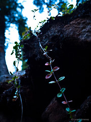
Life on the edge
Life on the edge
The trail became substantially easier as I descended, and by the time I had reached Laughing Falls and turned on to the Yoho Valley Trail, it was flat, wide - and quite frankly - boring. Ah well, at least the lack of challenge allowed me to make good time on it, which is just as well. Remember the late start that I had alluded to at the beginning of this post? Well, despite the speed I was able to maintain on this final part of the trek, I missed the evening light on Takakkaw Falls, and only caught the last of the sun's rays as they crept up the cliff face.
Takakkaw by the last light of the sun
Sun's last light falling on Takakkaw Falls
I suppose there's always next year; after all, this is a trail that I wouldn't hesitate to hike again.

Thursday, October 6, 2011

Pressing "pause" on life's movie


Riding Fool sign
So I've been more-or-less on the road for almost six months now. To me that seems like quite a lot - especially for a self-avowed non-traveler. My pace has definitely slowed considerably since I left Ottawa back in April. I haven't really had a strong urge to move on and explore in the past several weeks; recent forays to Tofino and the Juan de Fuca Strait were done with company, which certainly kept the enthusiasm up. Admittedly some of the lethargy is due to a nagging (but healing!) injury that I received during some ill-advised antics in Golden, BC, but mostly I think I've seen all the scenery I can handle and just need to sit an process everything for a bit, as well as give myself an opportunity to figure out what to do next.

Riding Fool interior

The old Tarbell's Store
So where am I? To date I've spent over a week in Cumberland, BC, a small former coal mining town in Vancouver Island's Comox Valley. It's a cute little town with a very strong sense of history and many heritage buildings lining its main street. There's rivers and creeks and trails and mountains nearby, and the ocean is a short 15-minute drive away. Mountain biking is supposedly epic, and from the trails I've been able to walk it seems that the reputation is well-deserved. I've been staying at The Riding Fool Hostel, which is on the second floor of the old Tarbell's hardware store, the remainder of which now houses a bike shop and cafe. This is a nice hostel, with a fantastic common area, well-laid-out kitchen, and comfortable beds. The folks who run the place are awesome and I can get discounts for weekly stays. What's not to like about this place? :)

I figure I'll kick around here for a while, maybe find a place to live and work and return to "real life". In the meantime, I'll get caught up on some blogging since there's a bunch of hikes I did in the Rockies for which I've got notes and pics, but never got around to posting. Keep your eye on this space!


Perseverance Creek
Perseverance Creek